Navigation questions
This section contains a number of self-test questions on the material in the Navigation section. For ease of use / reference, the questions are listed under the heading where you (should have) learned to answer them. Click on the heading to go to that section.
If you click on the question itself, the answer should appear in a pop-up message, provided your browser allows such things (sometimes excluded as a security measure). Try clicking this paragraph. But if it doesn't work, have a look at the end of the page.
Some questions involve the use of a chart, so I have chosen Admiralty Leisure Folio "The Solent and Approaches" - because this Folio will be useful for a lot of people to own. The questions are set so that any equivalent charts will work, but for positions note that the Chart Datum is WGS 84.
Position, Speed and Distance
1 True or false? "Latitude defines how far north or south you are, longitude how far east or west".
2 What is the latitude of the north pole?
3 How many degrees in a full circle?
4 A degree is divided into... how many of what sub-unit?
5 What are the lat long positions of these Isle of Wight locations:
a St Catherine's Point lighthouse;
b The Needles lighthouse;
c Yarmouth harbour entrance;
d The end of Ryde Pier;
e Saint Helen's Fort (off Bembridge).
6 True or false? "A nautical mile is defined as one minute of longitude".
7 True or False? "10 knots is faster than 10 m.p.h."
8 How many metres in a Nautical Mile?
9 What is a Cable; how many metres is a Cable?
10 What does a log measure?
Direction
1 What is South East expressed as a direction in degrees?
2 What is South West expressed as a direction in degrees?
3 True or False? "The difference in degrees between True North and Magnetic North is called Magnetic Variation"
4 True or False? "Magnetic Variation is the same everywhere in the Atlantic Ocean"
5 True or False? "Magnetic Variation at a particular location changes with time"
6 On the compass rose on a chart is printed: 5° 45' East 2006 (10' W). What is the magnetic variation in 2009?
7 You calculate that you want to steer a course of 292° True. The Magnetic Variation is 14° West. (Ignore Deviation.) What compass course do you steer?
8 You take a bearing on a landmark with the hand bearing compass: 186° Magnetic. The Magnetic Variation is 3° East. What is the True bearing to the landmark?
9 You take a bearing on a landmark with the hand bearing compass: 308° Magnetic. The Magnetic Variation is 4° West. What is the True bearing to the landmark?
10 You calculate that you want to steer a course of 055° True. Variation is 7° East. Deviation is 4° West. What compass course do you steer?
Estimated position: DRs and EPs
You depart the Needles Channel on a course of 148°T, headed for Ouistreham. You take a log reading by the Port-hand Lateral Buoy (50° 39.4 N 001° 37.3 W). After 1 hour you take another log reading:
1 Your boat has travelled 6.8 miles on the log. What is your DR position?
2 You are close hauled into a southerly wind. You estimate that your leeway is 4°. Which way will the leeway set you? What is your Estimated Position with leeway, ignoring tide?
3 You estimate the tidal stream for the last hour: 3.1 knots in direction 276° True. What is your EP position?
4 On that basis, what has your ground track been for the last hour?
Repeat the above questions for a passage to Alderney: you depart the same position on a course of 202° True:
5 DR after 6.8 miles?
6 EP with 4° leeway (southerly wind)?
7 EP position, with tide of 3.1 knots in direction 276° True?
8 Ground track?
9 You are a few miles from Ouistreham and the entrance to the buoyed fairway is on a bearing of 165° T. You are sailing with the wind aft of the beam, but only doing 4.5 knots through the water. The tide is setting 2.5 knots bearing 110° T. What is your course to steer? (Stick to True, don't convert to magnetic.) What will be your speed made good towards your destination?
Do this once or twice using the method illustrated, with the Breton Plotter, and see how quickly you can do it with a bit of practice. Then amaze your friends (and possibly the instructor) at the theory class. (Note: unless he has seen it before, the instructor may not believe your method works - until he works it out his way and gets the same answer.)
10 What would you do in this situation in real life - with a working GPS?
Fixing your Position
There are no concepts in this section on which to test your understanding.
Let me make a suggestion: if you haven't done so already, buy a hand-held GPS. Read the instructions and practice using it for position fixing. Be sure you know how to change the chart datum, and see how much difference using the wrong chart datum makes, when plotting your position on a chart. (It will, of course, make more difference on a small scale chart, e.g. of a harbour).
What GPS do you need?
Well you don't need any fancy maps or chart displays: any simple unit that is capable of working in nautical units and changing chart datum will do. The only functions I use on mine are: reading off latitude/longitude, waypoints (and distance and bearing to waypoint), and ground track (Course over Ground or COG).
Position Lines
1 You are in the West Solent and take the following bearings for a three-bearing fix: Jack in the Basket (entrance to Lymington river) 310° M; St James's Church tower Yarmouth 220° M; Hamstead Ledge buoy 076° M. The magnetic variation is 3° West. What is your position?
2 You are north of Cowes and take the following bearings for a three-bearing fix: Chimneys in East Cowes in transit on 179° M; Fawley Power Station chimney 320° M; Hill Head buoy 061° M. The magnetic variation is 3° West. What is your position?
3 In the East Solent you notice a church spire in transit with the Ferry Terminal on Ryde Pier. You see a yellow buoy less than half a mile to the south of your position, close to the transit. What is your approximate position?
4 You hurriedly take three other bearings: Fort Gilkicker 045° M; Horse Sand Fort 117° M; North Sturbridge N Cardinal buoy 104° M. The magneting variation is 3° West. Which bearing doesn't make sense? What is your position if you ignore that bearing? Assuming you read the compass correctly, can you see what would account for this gross error?
5 You pass No Man's Land Fort heading for Cowes, beating against the tide, and you want to stay as close to the Isle of Wight as possible but not go aground on Ryde Sands. Draw a suitable clearing line to No Man's Land Fort. What does the bearing to the Fort need to be, for you to be on the safe side of the line? Magnetic Variation is 3° West.
6 You use this clearing line until you are on the safe side of a second clearing line, drawn from the end of Ryde Pier. What bearing to Ryde Pier places you on the safe side of the second clearing line?
Answers
Position Speed and Distance: 1 True; 2 90° North; 3 360°; 4 60 minutes; 5 a 50° 34.52 North 001° 17.88 West; b 50° 39.73 North 001° 35.50 West; c 50° 42.42 North 001° 30.05 West; d 50° 44.38 North 001° 09.57 West; e 50° 42.30 North 001° 05.04 West; 6 False; 7 True, because 10 Nautical Miles is greater than 10 ststute miles; 8 1852 metres; 9 One tenth of a Nautical Mile, 185 metres; 10 Distance travelled through the water (in Nautical Miles); speed through the water (in knots)
Direction: 1 135°; 2 225°; 3 True; 4 False; 5 True (usually a few minutes per year); 6 5° 15' East; 7 306°; 8 189° True; 9 304° True; 10 052° Ship's compass (048° Magnetic)
How to Navigate: 1 DR: 50° 33.6 N 001° 31.7 W; 2 To the east - to port. 50° 33.8 N 001° 31.1 W; 3 EP: 50° 34.1 N 001° 35.9 W; 4 170° True; 5 DR: 50° 33.1 N 001° 41.4 W; 6 To the west - to starboard. 50° 33.3 N 001° 42.1 W; 7 EP: 50° 33.6 N 001° 46.8 W; 8 226° True; 9 192° T; approx 5.4 knots; 10 You are being set to the east, so aim off to the west (starboard) and adjust you course until course over ground (COG) is 165° T
Position Lines: 1 50 43.36 N 001 28.76 W; 2 50° 47.48 N 001° 17.45 W (you may not be afloat, but on the bright side you are unlikely to get run down by the Red Funnel ferry); 3 Approx 50° 45.5 N 001° 09.7 W; 4 The bearing to Horse Sand Fort: the other two and the transit agree with one another. 50° 45.52 N 001° 09.72 W. You incorrectly identified the sighted object: you were looking at No Man's Land Fort; 5 Greater than 104° M (101° T); 6 Less than 255° M (252° T)
Back to Navigation section
Tides questions
This section contains a number of self-test questions on the material in Chapter 2 Tides. For ease of use / reference, the questions are listed under the section heading where you (should have) learned to answer them! Click on the heading to go to that section.
If you click on the question itself, the answer should appear in a pop-up message, provided your browser allows such things (sometimes excluded as a security measure). So if that doesn't work, have a look at the end of the page.
Causes of Tides, Tidal Patterns
1 True or false? The sun has a greater effect on tides than the moon, because the sun has a greater mass than the moon.
2 True or false? The sun has no effect on tides, they are purely caused by the moon.
3 The typical pattern of tides is semi-diurnal. What does this mean?
4 True or false? Complex tidal patterns are caused by the way the water flows around the land.
5 Spring tides occur just after what phases of the moon?
6 Roughly how many weeks from a spring tide to the next neap tide?
7 Which statement is true? a) The depth of water is greater at high and low water springs than it is at high and low water neaps. b) The depth of water is greater at high water springs than it is at neaps, and less at low water springs than it is at neaps. c) The difference in heights of high and low water is less at springs than it is at neaps.
Tidal Heights
1 If the charted depth at a particular location is 4.1m: a) what is the depth there, when the height of tide is 2.6m? b) what is the minimum depth you are ever likely to encounter there?
2 A pontoon by a pub (which dries at low water) is shown on the chart with 1.4m drying height beside it. Your boat draws 1.8m. What height of tide do you require to tie up at the pontoon?
3 The local tide table for the day in question shows:
0815 .................. 1.9
1423 .................. 4.5
2057 .................. 2.0
At approximately what time can you time you arrival, and by when should you depart?
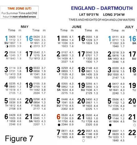
4 Using the tide table on the right, what is the tidal range in the morning of Thursday 19th May?
5 At what time - in British Summer Time - is low water on the morning of Friday 17th June?
6 You anchor in a sheltered bay near Dartmouth just after 4.00 pm (BST) on Saturday 2nd July. What is the minumum depth you should select for anchoring if you want to stay overnight in a boat that draws 1.8m?
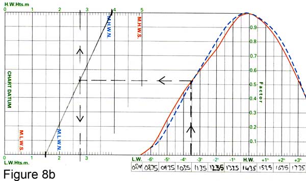
7 The tidal curve above has been marked up with the data for 18th June. Use the blue, dotted, curve as it is close to Neap tides. a) At approximately what time will the height of tide be 2m? b) Roughly what will the height of tide be, 2 hours before High Water?
8 Download the same tidal curve by clicking here.
Using the data for 6th June: a) What is the height of tide at 1250? b) At 1520? c) At 2000? d) Between what times will the height of tide be greater than 2.5m? e) Between what times will the height of tide be greater than 4m?
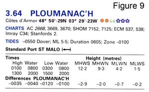 9 On the 23rd July 2008 the tide table entry for St Malo is as follows:
0446 ............ 2.1
1010 ............ 11.2
1658 ............ 2.5
2224 ............ 11.3
What is the corresponding data for Ploumanac'h?
10 On 25th August 2008 the tide table entry for St Malo is as follows:
0200 ............ 9.6
0711 ............ 4.2
1253 ............ 9.4
1956 ............ 4.4
To the nearest 10 minutes and 0.25m, what time and height are the morning low water and midday high water at Ploumanac'h? Estimate this quickly in your head, and after that work out the full day's data accurately.
Tidal Streams
For these questions, use the tidal diamond data from Admiralty Leisure Folio "The Solent and Approaches" (selected because this Folio will be useful for a lot of people to own). Alternatively you will find similar tidal stream information on other charts of the area, in Tidal Stream Atlases or in the Almanac.
With these chart folios, all the tidal information is usually gathered together on the back of one of the charts (Chart 5600.20 in the case of the 10th Edition of the Solent folio). With full-sized Admiralty charts, tidal data for each of the diamonds is printed in a table on the front of the individual chart.
1 Tidal diamond D is at a position four miles south of St Catherine's point (chart 5600.1). At this position, what is the tidal stream 3 hours after HW Portsmouth (spring tides)?
2 At the same point what is the tidal stream 5 hours before HW Portsmouth (neap tides)?
3 You fix your position at 50 32.1 North 001 44.3 West at 1130 BST on Thursday 24th July 2008. What estimate of tidal stream would you use to construct an EP over the following hour? (The tides are about half way between spring and neap, and see question 5 for tide table).
4 Compare the tidal streams at D with those at tidal diamond B, some 16 miles south of the coast at Christchurch. What do you notice about a) the direction and b) the speed of the tidal streams at the two positions? Looking at the "big picture", what do you make of the comparison: can you explain it?
5 Taking diamonds B, D and G as representative of what my be happening more generally in the English Channel to the south of the Isle of Wight, work out the times of the East-going (flood tide) and West-going (ebb tide) streams in this area on Thursday 24th July 2008. The entry in the Portsmouth tide table is as follows:
0233 ................. 4.4
0809 ................. 1.1
1507 ................. 4.5
2034 ................. 1.2
6 Look at the tidal diamonds in the Western Solent and the Needles Channel. You plan some gentle day sailing in the area. At what times do the west-going and east-going tidal streams begin on Saturday 21st June 2008? The entry in the Portsmouth tide table is:
0022 ................. 4.4
0603 ................. 1.1
1255 ................. 4.4
1819 ................. 1.3
7 Looking generally at the Western Solent (look at 5600.1 showing the whole of the Solent and Isle of Wight), where would you expect the west-going stream to be strongest and why? Confirm whether this is the case by looking at the tidal diamond data.
8 On Saturday 13th September 2008 you plan to sail round the outside of the Isle of Wight with some friends, starting from the Hamble. Assuming that you can sail at least 5 knots, make a plan for the passage so that you make the best use of the tides. HW Portsmouth is at 0959 and 2206 UT.
Answers
Explanation of Tides: 1 False. The sun does have a greater mass, but the moon has more effect on tides because it is closer; 2 False. The sun does have an effect - either reinforcing or counteracting the effect of the moon; 3 Two tidal cycles (i.e.two high waters and two low waters) in each 24 hour period; 4 True; 5 New moon and full moon; 6 One week; 7 b) is true, the other two are false.
Tidal Heights: 1 a) 6.7m (2.6 + 4.1)
b) 4.1m, at Lowest Astronomical Tide; 2 3.2m (1.4 to cover the mud, plus 1.8 for the boat to float); 3 After 1120, and before 1730.
Tide needs to be half way up, so you can arrive approx half way between low and high water and depart approx half way between high and low - but leave earlier or you may get stuck; 4 2.2m; 5 8.01am; 6 4.3m minimum (and leave a bit of extra margin).
You are arriving at approximately high water and the total drop (to the following morning's low water) is 2.5m; 7 a) 0945 UT b) 3.4m; 8 a) 1.8m b) 3.4m c) 3.6m d) between 1345 and 2110 UT e) between 1620 and 1930 UT; 9 0333 1.8 -
0932 8.6 - 1546 2.1 -
2148 8.7; 10 Approx answer: LW 1 hour earlier (ten past six), HW 35 mins earlier(twenty past twelve); and as it's neaps, LW height 0.7m less (3.5m), HW height 2m less (7.5m).
Accurate data:
0124 7.5 -
0608 3.5 -
1218 7.4 -
1856 3.7
Tidal Streams: 1 4.1 knots direction 276°; 2 1.8 knots direction 100°; 3 Time period is 1030 - 1130 UT, which is 4.5 to 3.5 hours before HW Portsmouth, so use 4 hours before as average. Tide at B is 088 2.1; at C it's 086 1.5, so take the mean value: direction 087° speed 1.8 knots; 4 Apart from small differences in direction, the general flow is "east" or "west" at exactly the same times in both locations: reflecting the general flow east or west in this part of the Engish Channel. Streams are generally faster at location D - presumably because it is close to the prominent headland (St Catherine's Point) sticking out into the channel, which the tide has to flow round; whereas B is opposite a bay; 5 E-going till about 0130; W-going 0230 - 0730; E-going 0830 - 1400; W-going 1500 - 2000; E-going from 2100;all times UT (as in Tide Table); 6 In West Solent, W-going starts 1 hour before HW Portsmouth, E-going starts 5 hours after HW. So the morning tide is East-going, turning West at around 1pm , and East again at 7pm. (Times BST.) At the Needles the streams change about an hour later; 7 The narrowest part of the Western Solent is off Hurst Point, and since the same volume of water has to move through there, it will be travelling faster. Tidal diamonds confirm this, with spring rates up around 4 knots; 8 Go clockwise, and you get 6 hours of favourable daytime tide round the outside of the Island. You want to be off Bembridge turning to the west at about 1000 UT when the west-going tide starts. You should make it to the Needles by 1600 UT when the tide turns to the East and in your favour for entry through the Needles Channel. So leave the Hamble River around 0630 UT and you should have favourable tides to get you down the Eastern Solent.
Back to Tides section
Charts questions
This section contains a number of self-test questions on the material in Chapter 3 Charts & Navigational Aids. For ease of use / reference, the questions are listed under the section heading where you (should have) learned to answer them! Click on the heading to go to that section.
If you click on the question itself, the answer should appear in a pop-up message, provided your browser allows such things (sometimes excluded as a security measure). So if that doesn't work, have a look at the end of the page.
Some questions involve the use of a chart, so we have chosen Admiralty Leisure Folio "The Solent and Approaches" - because this Folio will be useful for a lot of people to own. The questions are set so that any equivalent charts will work, but for positions note that the Chart Datum is WGS 84.
About Charts
1 True or false? Small-scale charts cover large areas, large-scale charts cover small areas.
2 A chart scale is stated as 1 : 150,000. Approximately how many nautical miles is represented by 1 cm on the chart? What is the easiest way to check this, and why in practice would you never bother with this calculation?
3 What feature of Mercator or Transverse Mercator projections makes them convenient for navigation?
4 True or false? The scale is the same all over a small scale Mercator projection chart.
5 True or false? When crossing an ocean, the shortest distance is a straight line on a Mercator projection chart.
6 True or false? Most UK Admiralty charts are produced to WGS 84 Datum, which is the normal default datum for GPS.
7 True or False? You should set your GPS to the chart datum for the particular chart you are using, otherwise positions plotted from the GPS onto the chart (and positions taken from the chart and entered into the GPS) will be in error.
8 You are using a chart to navigate round a remote island in the Caribbean, based on a very old survey. Which is the safest for avoiding dangers: carefully plotting you position from GPS, or position fixing from charted landmarks? What else should you do when approaching shallow areas?
Admiralty Charts
1 You are navigating towards an unfamiliar port using a small-scale chart for the passage. You get out a large-scale chart of the immediate approaches to the port, to decide how to tackle the pilotage into your destination. What is the first thing you should check when looking at the large-scale chart?
2 Refer to chart 5600.4 which shows the area 1 mile to the north-east of Hurst Point. You are in a yacht with 1.5m draught - you want to anchor for lunch, to wait for the tide to turn in your favour at low water. Without checking the tidal heights, is it OK to anchor in the area marked dark blue?
3 Can you anchor in the area marked light blue? What do you expect the holding to be like?
4 Refer to 5600.17. What height of tide do you require to reach Keyhaven YC?
5 You are in the western Solent using chart 5600.6. What landmarks do you think might be helpful for a position fix?
6 Refer to 5600.4. You have sailed down to the Needles on a sunny day with a cool breeze from the north. Someone suggests anchoring under the cliffs just south of West High Down for lunch. Do you think this is a good idea?
7 The same person advises Colwell Bay for tea on the way home. Is this OK?
8 Why do you think you should take care entering the Needles Channel in heavy weather?
9 Have you bought Chart 5011 yet? Why not?
Navigational Aids
1 You are heading north west, up the side of a shipping channel, in the dark. You have about 5 miles to run to your destination. Ahead of you is a white light flashing 3 every 10s: you recognise this as an East Cardinal, meaning "clear water to the east". Should you alter course to pass to the east side of it?
2 In the UK, Europe, Mediterranean etc (not USA) channels are marked with red and green lateral marks. In which direction should you keep red marks to port when following the channel?
3 True or false? It is compulsory to keep within a channel marked by red and green lateral marks in all UK harbours.
4 True or false? Red and green marks are the opposite way round in the USA.
5 A north cardinal mark indicates a danger: on which side of the buoy or beacon is the danger that it indicates?
6 Identify the following:
a) 
b) ![]()
c) 
d) 
e) 
f) 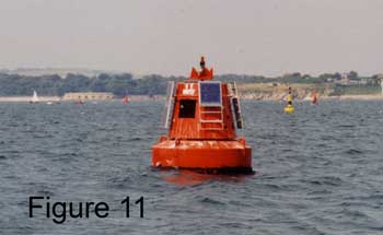
g) 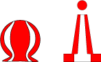
h) 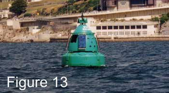
i) 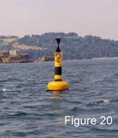
7 At night you see a white light, flashing six times followed by a long flash. Next to it is a white light flashing nine times. What are they?
8 You see continuous green flashing ahead of you. What kind of mark is it, and what light characteristics will you look for when you try to identify it on the chart?
9 The following are the light characteristics for St Catherine's Point Light:
Fl.5s41m26M & F.R.35m13M
Decode this.
10 Needles Light has the following characteristics:
Oc(2)WRG.20s24m17-13M
Decode this.
Answers
About Charts: 1 True, and if you memorise this it's probably the easiest way to remember which way round it is; 2 150,000 cm, which is 1.5km, or approx 0.8 nautical miles (1 nm = 1852m). To check, put a ruler against the latitude scale on the side of the chart (e.g. on chart 5600.1). In practice you just use the latitude scale to measure off nautical miles (1nm is one minute of latitude); 3 Straight lines are constant true bearings or directions; 4 False. The scale varies with latitude; 5 Generally False. The only straight lines which are also Great Circles (the shortest distance) are due North/South; 6 True - but you may still come across older or non-UK charts drawn to other datums; 7 True. The size of the error will depend on the chart datum and the (incorrect) datum the GPS is set to; and the error will be more significant when working with large scale charts; 8 Position fixing from landmarks, because this is how the chart was drawn in the first place. Latitude and longitude may be highly unreliable.
Admiralty Charts: 1 The scale - by looking at the scale of latitude on the side of the chart. This will enable you to visualise the area represented on the chart, and start to decide on your pilotage plan; 2 No. You may go aground at low water (this area is less than 2m LAT); 3 Yes - the light blue area is between 2m and 5m LAT so it should be OK at all states of the tide. The holding may not be good: G.bkSh.Wd stands for gravel; broken shells; weed (including Kelp); 4 From the chart the least depth seems to be just north of Keyhaven Lake - 0.1m drying height. So you need a height of tide of at least 1.6m to float there. The channel seems very narrow (< 20m) approaching Keyhaven, with drying heights of over 1m to either side. Seek advice from the YC; 5 On the north side: a 44m monument at Walhampton; a tower at St Leonard's Farm W of Beaulieu River; Old Coastguard Cottages just W of Beaulieu River; and not much else, maybe the 2 houses and various navigation aid beacons to the east of Beaulieu River. On the south side: Fort Victoria W of Yarmouth; church tower in Yarmouth; flagpole and lookout on 40m Shepheards Hill E of Newtown River; 6 No - there are numerous dangerous rocks close to the coast, and further off it may be too deep to anchor; 7 There are various dangers in this bay too, but if you approach with caution, keeping the Hotel on a bearing of approx 298°T, you should be able to anchor safely; 8 There are extensive tidal overfalls marked, extending W of Needles Point, and a warning in the Notes headed OVERFALLS; 9 There is no excuse!
Navigational Aids: 1 If you do, you will go aground after you pass it. You are in Calshot Reach (chart 5600.8), heading for Southampton, and you are observing the east cardinal beacon on Hamble Spit. The correct answer is "I don't know", because until you have identified the mark on the chart, you don't; 2 In the direction of the flooding tide, or into harbour; in the direction indicated by special symbol on the chart when this is not obvious; 3 False. In some cases it may be compulsory for small vessels to keep OUT of a marked channel which is intended for large vessels; 4 True; 5 On the south side; 6 a) South Cardinal b) Isolated Danger c) East Cardinal d) Port-hand Lateral e) North Cardinal f) Port-hand Lateral g) Safe Water h) Starboard-hand Lateral i) West Cardinal; 7 The first is a South Cardinal, and the second a West Cardinal; 8 It is a starboard-hand lateral mark. Look for Fl.G. or Q.G. or VQ.G. depending on the frequency of the flashing; 9 Single flash every 5 seconds, elevation of light 41 metres above MHWS, nominal range of light 26 nautical miles (the light will be white, as its colour is not mentioned); AND fixed red at elevation 35 metres with nominal range of 13 nautical miles. The chart shows the sectors in which each of these lights can be observed; 10 Occulting twice (meaning ON for most of the time and going OFF twice) colours white, red and green in sectors (which are marked on the chart); occulting pattern repeats every 20 seconds; elevation of light 24 metres above MHWS, nominal range of lights from 17 to 13 nautical miles depending on colour.
Back to Charts section
COLREG questions
This section contains a number of self-test questions on the material in Chapter 4 COLREGS. For ease of use / reference, the questions are listed under the section heading where you (should have) learned to answer them! Click on the heading to go to that section.
If you click on the question itself, the answer should appear in a pop-up message, provided your browser allows such things (sometimes excluded as a security measure). So if that doesn't work, have a look at the end of the page.
Rules of the Road
1 How do you tell if a collision risk with another vessel exists?
2 If you are the give-way vessel, you are required to take action to avoid the potential collision. In the rules, what are the three important qualifiers to the action you take?
3 If you are the stand-on vessel you are required to do what? And if the other vessel is not (for whatever reason) taking any action to avoid the collision, what do you do then?
4 True or false? If you are sailing past a motor boat from behind (i.e. overtaking him) he has to keep out of your way.
5 You are sailing east with a northerly wind. Another vessel is sailing towards you in more or less the oppostie direction. Which is the give-way vessel?
6 You are on a spinnaker run on port tack. You see a sailing vessel beating upwind towards you. Which is the give-way vessel?
7 You are in a sailing boat motoring in open water away from harbour, and a fishing vessel is motoring in; he is on your port bow and appears to be on collision course. What do you do?
8 True or false? If you are in a narrow channel you keep to the right and pass vessels coming in the opposite direction "port to port", and if you are motoring in open water and another boat is motoring head-on to you, you do the same i.e. alter course to starboard and pass port to port.
9 What does "not under command" mean?
10 Name four classes of motor vessel that sailing vessels are required to keep out of their way.
11 You are sailing across a Traffic Separation Scheme which was difficult to avoid when planning your passage. What direction do you cross in? Do motor vessels have to keep out of your way? What do you do if the wind drops?
12 You are sailing in poor visibility, and you see on radar another vessel that must be motoring, on a constant bearing. You cannot see the other vessel but you know it must be a motor boat. Do you hold your course and speed as the stand-on vessel?
Lights and Shapes
1 You charter a 35 ft sailing boat. What lights do you expect to find on it? What shapes might you find?
2 What shape do you display at anchor? What light do you display anchored at night?
3 Can you use a mast-top tri-colour light when motoring?
4 You are out at sea and you see a single white light. What is it likely to be? What rule will apply if you are getting closer to it?
5 You are sailing on a port tack. Fine on your port bow you see a single green light on a constant bearing. What do you do?
6 You are motoring and ahead to port you see the green side light and masthead light of another motor boat, on a constant bearing. What do you do? What do you hope to see?
7 What are the day shapes for:
a) Not under command?
b) Engaged in fishing?
c) Restricted in ability to manoeuvre?
d) At anchor?
8 You see a small inflatable boat ahead of you, stationary in the water, flying a blue and white flag. Despite the fact that you have altered course to avoid a collision, someone is madly waving at you from the inflatable. Why would this be? What should you do?
9 What are the lights for:
a) Restricted in ability to manoeuvre?
b) Not under command?
c) Fishing? (Two types for two types of fishing)
d) Pilot vessel?
10 At night you are approaching what looks like an oil rig, lit up like a christmas tree, where none is charted. Some way off you see a yellow light over a white light. What's going on?
Sound and Light Signals
1 You are at the helm sailing in Plymouth Sound, heading in towards the marina for shelter, with almost no sail, a frightened crew and 35 knots of wind behind you. Visibility is poor, and suddenly you see the Santander Ferry coming up behind you. You want to go more to starboard, but he is getting closer and you are keen to keep out of his way. Suddenly he gives two short blasts on the ship's whistle. What does this tell you, and what do you do?
2 Do you think that in the above scenario, it would be a good time to go below and look up sound signals?
3 You are manoeuvring to leave a harbour wall by reversing out, and another yacht is coming in, evidently looking for a berth, and threatening to get in your way. What sound signal could you use if you have your horn handy?
4 What sound signal are you required to make in foggy conditions:
a) motoring?
b) sailing?
5 What do you do if you hear five short blasts from a large vessel?
Distress Signals
1 What do you think is the most effective method of issuing a distress signal from a small yacht or motor boat?
2 Is a white flare a distress signal?
3 A large number of small boats and most liferafts carry distress flares. What are the three types of distress flare?
ANSWERS
Rules of the Road: 1 You observe the bearing to the other vessel, and if it is constant a collision risk exists; 2 It must be early, obvious (to the other vessel) and substatial; 3 Hold your course and speed. You are allowed to take action to avoid the collision, but take care in case he, also, takes action. Do something that won't result in a difficult situation if he does, e.g. turn away from him; 4 False. You are the overtaking vessel, even if you are a sailing boat overtaking a motor boat; 5 You are on port tack, and the other must be on starboard, so you are the give-way vessel; 6 You are. Either he is on starboard tack, or else he is on the same tack as you, and you are the windward vessel; 7 Hold your course and speed. He is in your port sector, and you will be in his starboard sector if he is crossing and on a collision course. He is not "engaged in fishing". However, plan the manoeuvre you will make if he fails to take any action. E.g. plan to turn away from him, so that you are not in trouble if he suddenly turns to go behind you; 8 True; 9 Unable to manoeuvre because a fault or problem; 10 1) Engaged in fishing 2) Constrained by draught 3) Restricted in ability to manoeuvre 4) Not under command; 11 As nearly as possible at rightangles to the direction of traffic following the scheme. Only if they are other small vessels not following the scheme (and not engaged in fishing, restricted in ability to manoeuvre, or not under command of course). You must keep out of the way of vessels following the traffic separation scheme. Start your engine; 12 No. See Rule 19, which applies to vessels not in sight of one another. There is no distinction between the actions of different types of vessel.
Lights and Shapes: 1 Side lights (red and green) and stern light (white). A masthead light (forward looking, white) which can be switched on independently when motoring. Ideally an all-round anchoring light and possibly a tri-colour light at the top of the mast. An anchor ball, and a motoring cone (the latter rarely used in the UK!); 2 A black ball (or folding circular shape). An all-round white light; 3 No. Your steaming light needs to be above the red and green sidelights, so the latter need to be at deck level with the steaming light above them on the mast; 4 The stern light of another vessel. You are the overtaking vessel, and must keep out of his way until you are well clear; 5 You alter course to put him on your starboard bow. He must be on starboard tack and he is crossing you, so you are the give-way vessel. In making your manoeuvre it is important to show him your other side light, so that he knows you have altered course to avoid him; 6 You are the stand-on vessel as he is in your port sector. Hold your course and speed, and you hope to see his red side light (or both red and green) when he has altered course to go behind you; 7 a) Two balls in vertical alignment; b) Two cones with apexes towards each other, in vertical alignment; c) Ball - diamond - ball in vertical alignment; d) A ball; 8 The blue and white A flag means "I have a diver down. Keep well clear". This is probably an amateur diving boat and he has divers in the water - they may not be particularly close to the boat, so give him a wide berth (and keep a look-out for divers, surface marker buoys or patches of bubbles); 9 a) All-round red over white over red, aligned vertically; b) Two all-round reds in vertical alignment; c) Two all-round lights in vertical alignment: green over white (trawling) or red over white (fishing other than trawling); d) Two all-round lights in vertical alignment: white over red; 10 It is a rig, being towed by a vessel.
Sound and Light Signals: 1 He is telling you that he is about to turn to port - so if you go to starboard you will be out of his way; 2 This exact situation has happened to me, and I was very thankful that I understood what was intended to be a helpful communication from the larger vessel; 3 You could give three short blasts to tell him you are reversing (and incidentally leaving the space for him). Whether he a) understands, or b) gets out of your way, is another question; 4 a) One prolonged blast at intervals of about 2 minutes; b) One prolonged and two short blasts at intervals of about 2 minutes; 5 Clearly he thinks someone is in his way, so a) check whether it is you, and b) if so, do something about it quickly.
Distress Signals: 1 A MAYDAY call on the VHF. If you don't have a VHF, buy one - even hand-held - and do the one-day course to get an operator's licence; 2 No. It is used to draw attention to a vessel e.g. for collision avoidence; 3 a) Red parachute flare b) Red hand flare c) Orange smoke.
Back to COLREG section
Weather questions
This section contains a number of self-test questions on the material in Chapter 5 Weather. For ease of use / reference, the questions are listed under the section heading where you (should have) learned to answer them! Click on the heading to go to that section.
If you click on the question itself, the answer should appear in a pop-up message, provided your browser allows such things (sometimes excluded as a security measure). So if that doesn't work, have a look at the end of the page.
Weather Forecasts
1 What do "veering" and "backing" mean?
2 What do "imminent", "soon" and "later" mean?
3 What do "moderate" and "poor" visibility mean?
4 Roughly how many knots is a Force 5 wind?
5 You listen to a forecast, deciding whether to take a small boat out that morning. The forecast is Force 2 to 3, increasing Force 6 to 7 "later". What other information do you need to know when to expect the stronger wind?
6 You look at the notice board at a marina, and see a five-day forecast. You also see that you are now on day 4 of the forecast. Do you use this information? What do you do?
Local Weather
1 On a bright sunny day with a brisk wind from the north, you find a sheltered cove with a good beach on the south-facing coast of Lyme Bay. Paddling in flat calm conditions, with the odd little gust of wind, what would you expect conditions to be like further off-shore? What advice would you give to an inexperienced windsurfer setting out from the beach?
2 You are sailing from Falmouth to Fowey in 16 to 18 knots of wind and it seems to be picking up slightly if anything - anything stronger and you would want to reef the sails. You are about 2 miles away from Dodman Point, a prominent headland. What do you do?
3 What's the best indication of the wind at sea, when you are in the flat calm of a sheltered harbour early in the morning?
4 You are beating up-wind parallel to the coast, in a light breeze, at 9 a.m. on a fine summer day. What change in wind direction might you expect in the next hour or two? Would it help to tack well away from the shore, or might it be better to stay reasonably close to the coast?
5 It is a sunny cold clear day in early spring, and you see a large black cloud and heavy rain shower up ahead. What do you do? After the rain shower has gone through, the wind drops to about 5 knots. Someone suggests putting up a larger headsail. What do you do?
6 After a clear night in September, you wake up in a harbour to fog, with visibility of about 200m. Is it likely to:
a) get worse during the day
b) be clearer or thicker out to sea?
7 Sailing across the English channel in the afternoon in early summer, with a light warm south westerly wind, you notice fog up ahead. What is the likely cause of this fog? What conditions do you expect for the rest of the trip?
Wide Area Weather
1 In which direction does the wind circulate round an area of low pressure in the northern hemisphere?
2 What term is used to describe the thin area of high pressure you get between two lows?
3 What are the lines of equal pressure on a synoptic chart called?
4 True or false? You generally get fair weather with an anticyclone.
5 What is the name of the "force" that explains why things move in a curved path on a rotating surface (rotating frame of reference)?
6 True or false? When the isobars are close together you get strong winds associated with the steep pressure gradient.
7 The barometer has been falling for several hours, the sky clouded over - high cloud at first, getting lower, and it's now drizzling. What is going on? What will happen to the wind?
8 A few hours later the wind is Force 6 from the south west when suddenly the sky clears and the sun comes out. What is happening, and what do you expect the wind to do?
9 A few hours later the wind backs and strengthens. It is raining again. What's happening?
10 When the rain stops again, is the air likely to be warmer or colder? The barometer rises. Will there be more rain?
ANSWERS
Weather Forecasts: 1 Both mean the wind is changing direction: veering in a clockwise direction (south - west - north) and backing in an anticlockwise direction; 2 They refer to the time when a forecasted event will happen: imminent is within 6 hours of the time of the forecast; soon is between 6 and 12 hours of the time of the forecast; later is 12 to 24 hours from the time of forecast; 3 Moderate is between 2 and 5 miles: poor is between 1000m and 2 miles; 4 Force 5 is defined as 17 - 21 knots. The apparent wind will be stronger if you are sailing into it, lighter if you are going downwind; 5 You need to know the time of the forecast (NOT the time when it was broadcast); 6 Look at it for interest, but the forcast is very unlikely to be accurate. Tell the marina office that it is misleading to display an old forecast, and ask them for an up-to-date one. Then, for interest, compare the new forecast with the old one.
Local Weather: 1 Away from the shelter of the coast the wind will be brisk and the waves reasonably large for a small craft. Tell them that they might have considerable difficulty getting back to shore if they go out any distance; 2 Expect the wind to pick up as you approach the headland - so put the reef in now; 3 Look at the speed and direction of movement of the clouds; or flags/trees etc on the top of a hill, or see if trees/flags lower down are being affected by gusts. Listen to the forecast, or ask someone who is coming in! 4 You expect the wind to be angled more on-shore as the sea breeze develops. If this new direction is helpful to your progress (e.g. allowing longer tacks nearly parallel to the coast) stay reasonably close in, because further out to sea, the sea breeze effect will be weaker or absent; 5 Expect a sharp (and possibly very sudden) increase in wind in the vicinity of the shower: get some sail down. Wait before putting more sail up. The wind is light because the shower, which has just passed, is counteracting the general wind. Expect the wind to get back to where is was before the shower arrived; 6 This is radiation fog. It will either clear up as the sun warms the air, or it will hang around if the sun isn't strong enough. It probably hasn't formed out at sea, so you expect it to be clearer there; 7 This is advection fog, caused when warm damp air blows over cold sea. It may have formed over quite a wide area, so be prepared for it to be around for the rest of the passage (it will probably clear only when the wind changes).
Wide Area Weather: 1 Anticlockwise (westerlies to the south of its centre, easterlies to the north); 2 A ridge; 3 Isobars; 4 True. An anticyclone is an area of high pressure; 5 Coriolis; 6 True; 7 This is the typical approach of a warm front with a low pressure system. The wind will pick up, probably from the south west; 8 The front has passed, and the wind will veer quite quickly to the west or north west - and possibly moderate as the warm front recedes; 9 This is the typical pattern for an Atlantic low: a cold front is approaching; 10 Colder. There may be heavy sharp showers in the wake of the cold front.
Back to Weather section