About Radar - and Learning About Radar
Using radar is not at all like using a chart plotter. With a chart plotter you will quickly get the hang of it: the display is exactly like a chart, with the same information you are used to seeing on a chart.
Radar gives you a genuinely new source of information, and it's an extraordinarily powerful tool, but the picture very different. You need to know what it is showing you - and what it is not showing you.
To benefit from radar, you have to learn how to use it and how to interpret the information it gives you.
Example 1 : Radar Image of Land
The radar can ‘see’ the land, which is very useful for navigating at night or in poor visibility. But the shape of the shoreline on the radar display is very different from what you see on the chart plotter.
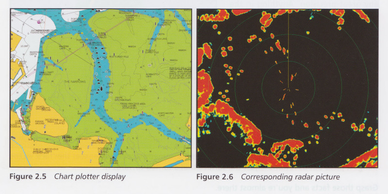
There are several reasons for this (explained more fully in the book).
• From a distance, the shoreline might be below the horizon. (You get the same effect when you first sight land from out at sea: what you see first is usually high ground, some distance inland.)
• The radar image depends on the type of land. Rocky cliffs show up well; mud flats may not show up at all.
• The radar beam is wide, so the ‘picture’ will be less distinct than the chart, particularly at a distance.
• The radar won't detect anything that's hidden behind something else, e.g. it can't show you the coastline on the far side of an island.
So the information you’re getting is extremely useful, but may be incomplete in ways that are not immediately obvious. It will, for example, give you a very accurate distance off if you are close to a steep rocky shore. However it won’t always give you an image of land that you can recognise by its shape.
Example 2: Collision Avoidance in Low Visibility
In fog, radar is the only means* of detecting other vessels and objects on the water. This is one of the most useful applications of radar, but it's not simple:
• You have to be careful to set the radar up correctly. You don’t want the display to be covered with misleading ‘false’ returns, and at the same time you don’t want to miss small ‘real’ returns.
• When you do detect another vessel, you need to know if there is a risk of collision.
• If there is a collision risk, you need to work out what that vessel is doing and how to avoid it. There are different COLREG rules for vessels “in sight of one another” and vessels “in restricted visibility”.
Unless you know what you are doing, poor assumptions and mistaken actions can easily make the situation worse.
[*Note: AIS is also very helpful: if the other vessel has a transmitter, your AIS receiver can display the position (and other information) sent by radio from the other vessel. AIS is also covered in the book.]
What this means ...
Basic Day Skipper or Yachtmaster® training does not cover radar.
To use it requires knowledge, skill, and of course practice. Essential Boat Radar is an excellent place to start, and is used by many radar instructors. It is somewhat longer and more comprehensive than the RYA's "Introduction to Radar".
I would recommend you attend the RYA One-day Radar Course which enables you to practice with the guidance of an experienced user and instructor. Essential Boat Radar makes a very good companion to the course, and a comprehensive reference for later when you are practising on your own vessel. (See Instructors' reviews, below).
Above all use your radar regularly in good and moderate visibility, and practise the exercises given in the book. This will help you to gain confidence for poorer visibility.
Essential Boat Radar: About the Book
This book concentrates on what the amateur radar operator needs:
• you need to know enough about how radar works to understand what it's showing you
• you need to know how to use it for collision avoidance and pilotage.
Overview
Initially the book explains simply and clearly how radar works: and explains the basic controls you'll find on all makes of radar, and how to use them to get a good picture.
The following chapter is all about collision avoidance: probably the most important application of radar. As part of this, the chapter also goes into AIS and the relevant COLREGs.
As with all chapters in the book, there are suggestions for practical exercises, and this is really a must: please don’t wait until you get caught in the fog before you try using the radar.
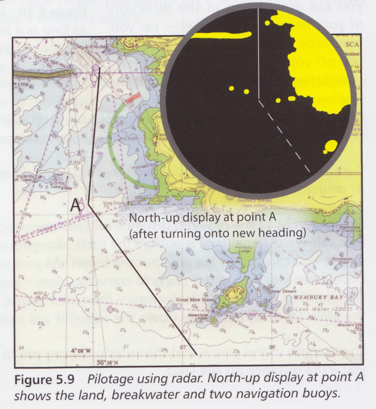
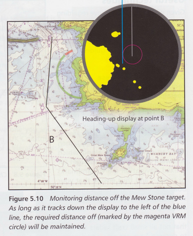
Chapter 5 is how to use radar for navigation and pilotage. Radar is particularly good at measuring distance from a detected object – far better than our visual estimates – and this can be used to construct useful position lines and clearing lines (position and clearing lines are explained in case you’ve forgotten …).
Chapter 6 explains more about radar ‘science’, so you can understand it a bit more, and chapter 7 explains the more exciting functionality you can get by integrating radar with other instruments (heading sensor, GPS, chart plotter, AIS etc.).
To buy this book
You can buy this book from Fernhurst Books, or from Amazon, or from any good bookshop or chandlery (complain if they don't have it!)
Some comments from radar course instructors
"Thank you for your no nonsense Essential Boat RADAR book, presented with superb clarity. I offer an advanced course similar to the MCA Small Boats Navigation and RADAR course in which each student has an individual copy of you book for reference."
"I looked at your book in the Force 4 chandlery at Swanwick today and was impressed. I have recommended it on my website. It's useful to include AIS, which I cover on radar courses, though it is still not part of the RYA syllabus, but I think it will come some day"
"Bill I've just read through the article and it's very comprehensive and easy to understand. I like your summaries and the article should be added to every conventional radar course. Well done! If your book reads as well as this it should be a much better course companion. It would be good to have a clear but comprehensive book to accompany every radar."
What is 'Broadband' Radar?
'Broadband' refers to a radar technology that was released to the leisure/small craft marine market shortly after Essential Boat Radar was published. The correct name for the technology is Frequency Modulated Continuous Wave (FMCW).
(Use of the word 'Broadband' is, to some extent, marketing hype, because it has nothing whatever to do with Broadband internet access or, indeed, with any kind of increased 'bandwidth' or information content.)
The difference is the method by which the radar measures range. Instead of using microwave pulses, FMCW uses a continuous transmission of microwaves with varying frequency. This illustrated below, and is fully described in the article (see link at the bottom of the page).
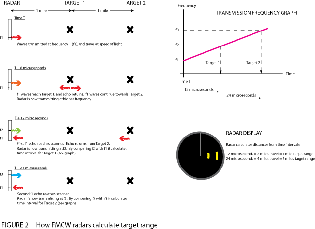
For a full description of FMCW ('Broadband') radar, and comparison to pulse radar, read the article on this link.
Aside from the description of pulse radar ranging, everything in Essential Boat Radar applies to FMCW 'Broadband' radar.